
Since Iceland became one of the most popular travel destinations on Earth (I guess…), fewer and fewer places here remain mere secrets of the locals. Some areas have gotten absolutely swarmed while others are still relatively untouched. One of those hidden gems is the Reykjanes peninsula. Despite its prime location and easy access, the rocky peninsula is still being overlooked by both Icelanders and foreign travelers. After moving there a few years back, I think I’m safe to say I‘ve spent more time than most exploring the rugged Reykjanes which keeps surprising me.
Since spring is technically here (not really though) and summer just around the corner (definitely not), I wanted to share with you a few of my favourite hikes in Reykjanes. They‘re all pretty accessible and I’ll put some info about each one including location, difficulty and time. Usually there are more than one ways to go so you can always adjust the difficulty and time to your own physical state by setting the pace and/or picking different routes. Also, I haven’t tracked my routes there but when I do I’ll add them to the blog.
If you enjoy this kind of content, let me know in the comments and make sure you subscribe to the newsletter. Liking and sharing also helps a lot.
GOOGLE MAPS: I’ll leave a lot of Google Maps links/coordinates throughout this post so I recommend you save those to your map so you’ll have an easier time following the dots.
DISCLAIMER: Part of what makes Reykjanes unique for hiking is the lack of marked trails, poles and signs/markers. At the same time, that can make it hard to find your way around. Always make sure you take all the safety precautions before starting your hike (supplies and appropriate clothes, phone, charger, food, etc.) and make sure you have enough daylight left, The paths I’m suggesting should never feel dangerous. They might be a bit rough and steep at times, but you should never need any technical climbing abilities to do them.

STAPATINDAR
Parking: 63°55'33.6"N 21°59'51.6"W | Time: 1-2 hours | Difficulty: 2/5 | Best time of day: Sunrise
Right by Kleifarvatn is a mountain ridge that runs along the whole lake. That area is enough for days of fun but also the perfect place for quick up and downs of selected peaks, one of my favourite being Stapatindar. Parking by the lake (see coordinates above) you basically just walk straight up the side of the ridge. There’s no designated path so just find your way through the rocks and rough sand until you can’t get any higher (mind the moss!). There’s no technical climbing and you don’t need any specific gear, just hiking boots and clothes that match that days weather. After you’ve enjoyed your moment of glory at the top, you can either go back the same way you came or move along the ridge in either direction and find a different route down (you should never have to do any serious climbing). That ridge is simply a huge playground for you to explore.

GRÆNADYNGJA
Parking: A. 63°56'51.9"N 22°05'18.4"W / B (4x4): 63°55'56.6"N 22°06'13.8"W | Time: 2 hours | Difficulty: 3/5 | Best time of day: Sunrise/sunset.
Overlooking the most beautiful highlands of the lowlands (Sogin) we have Grænadyngja, a pretty flat-topped but beautiful mountain in the dead center of the peninsula. Grænadyngja literally translates to a “green shield volcano” and during the summer months it definitely is green. The best part about this hike is simply the hike itself and then the view you get of the geothermal spot and the two lakes on both sides. There are two parking spots and then a few ways to get to the top, I’ll cover two of them (one short and one a bit longer, my favourite). For my favourite route you don’t need a special car, but for the shorter route you’ll need a pretty capable 4x4.
Option 1: Park as close as you can to this spot (drive carefully when you turn off route 41, it’s a rough rode but doable for most cars). From there you’ll see a small ravine. You can climb/hike up the ravine but you also have the option of simply walking up the hill on your left. When you’re up, make your way to this spot and start hiking up. This is my favourite part of the hike. After scrambling up the rocks you enter a field of grass, surrounded by rocky cliffs. It feels like you’re in the middle of nowhere. Now keep walking until you see a suitable path up on your right (I think it was either this spot or this one - no technical ability needed). Take your time with this part - you’re almost at the top. When you reach the top, keep walking along the grassy plateau until you see two lakes and a beautiful geothermal area. Stop there and enjoy!
Option 2: Either park here or drive further up and park here (can get gnarly driving up there). From there, make your way east towards a small stream. Cross the stream and head towards a brown ridge on your left (approximately here). Find your way up to the ridge (steep but shouldn’t feel dangerous at all). When you get to the top, head north-east, up the slopes towards Grænadyngja. You’re basically hiking towards the moss and green grass (away from the geothermal muddy area). There’s no super obvious path up there but if you’re constantly moving towards this point you’re good.
Connecting the routes: It can be fun to make this a loop out of this hike. Start at one of the parking options, hike up Grænadyngja and down the other way to the other parking option. From there you can basically follow the road to your car.

TRÖLLADYNGJA
Parking: 63°55'56.6"N 22°06'13.8"W | Time: 2 hours | Difficulty: 3/5 | Best time of day: Sunrise/sunset.
NOTE: Trölladyngja is literally next to Grænadyngja, so the driving part and parking options will be similar AND it’s perfect to combine them into one big hike (double Dingy). It also has an incredible view, both to the west towards Mt. Keilir and towards Sogin to the south. Tröll means trolls and dyngja is a shield volcano, and when you do the hike, it definitely feels a bit trolly with it’s sharp rocks and lack of life.
Park as close as you can to this spot (drive carefully when you turn off route 41, it’s a rough rode but doable for most cars). From there you’ll see a small ravine. You can climb/hike up the ravine but you also have the option of simply walking up the hill on your left. When you’re up, make your way south-west towards the base of Trölladyngja. You should know when you’re on the right track towards the top but it can be quite tricky to find. And once again, you should never have to climb or do anything sketchy during this hike. When you’ve reached the top, simply enjoy the views! I’ve always taken the same route down but there is an option to keep going and coming down on the other side.
Connecting Trölladyngja and Grænadyngja (3 hours): Since these are right next to each other, it’s ideal to check both of them of in the same trip. I’d recommend parking here (north-east of Trölladyngja) and start by doing Option 1 to the top of Grænadyngja. Then head down towards Sogin (south) and then west towards Trölladyngja. From there you’re basically walking between Trölladyngja and Grænadyngja. Keep heading north until you find a suitable way to hike up Trölladyngja (somewhere around here). When you’ve enjoyed the views from the top, simply go back down the same way you came (it is possible to go down on the other side too) and towards the parking spot. Again, no need for technical or dangerous climbing.

BONUS HIKE: HVERAFJALL
Parking: 63°53'44.4"N 22°03'09.0"W | Time: 1 hour | Difficulty: 2/5 | Best time of day: Sunrise/sunset.
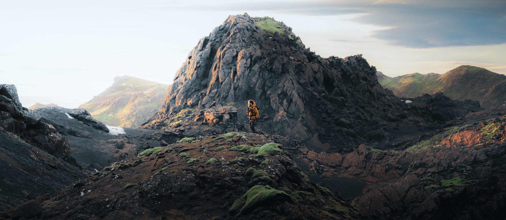
Hverafjall is perfect for those looking for a short hike with children but also offers some nice views and interesting geothermal features. Parking next to Seltún, an incredible little geothermal spot, you’ll follow the paths to the west for a few minutes (you know you’re going the right way when you find a short chain). Then you’ll basically keep going the only way that makes sense until reaching the top. From there you have a beautiful view overlooking Grænavatn and Kleifarvatn. If you want a bit more, make you’re way north-east towards this little peak (that’s the one in the banner photo). For a loop, keep going east and you’ll come down on the other side of Seltún.
don’t stop there though
Reykjanes has endless options for hikes, both on level ground and with some elevation. And even though the mountains aren’t super high, they’re often rugged and have optional routes that can can be somewhat technical and challenging. But the best part is, you’ll mostly have them to yourself and you’ll feel like you’re in the middle of the highlands even though you only had to drive about 30 minutes from the capital. I’ll definitely be spending some time there next summer, feel free to hit me up when you’re in the area and let’s see we can make a fun Reykjanes hike happen.
Again, if you enjoy this kind of content, let me know in the comments and make sure you subscribe to the newsletter. Liking and sharing also helps a lot.
See you in the next one!